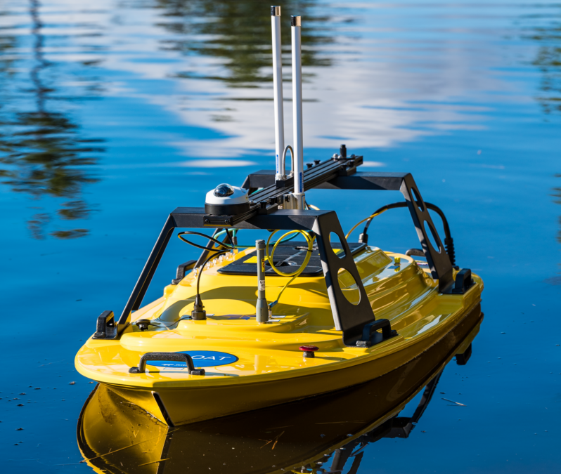
Feature photo: The Z-Boat is like a drone, but instead of flying through the air, it skims over the water. It, too, can cover pre-programmed tracts, and it is a helpful tool for accessing areas with safety or accessibility concerns for personnel.
Whether realized or not, remote sensing is now something ingrained into everyday life. Remote sensing technologies are utilized in self-driving cars and iPhone cameras among other things. In many ways, it makes life easier without some people ever noticing. However, the curious mind might wonder what this non-descript term implies.
In its most simple terms, remote sensing is the capability to measure something somewhere without being on-site. This broad definition includes technologies on a variety of scales. For example, a microscope allows someone to see something so tiny they could not otherwise visualize it with the naked eye. On the other hand, satellite imagery collected from Outer Space can provide insight about a specific location while someone views it from a computer on the other side of the world. In addition to microscopes and satellites, remote sensing tools include drones and autonomous vehicles. Various sensors, or payloads, can be fixed to the preferred method of transport to accomplish the desired task.
At the Coastal Studies Institute, scientists use remote sensing as an aid for their research methodologies. “You can collect massive amounts of data in short periods of time,” explains Department of Coastal Studies Chair and CSI scientist Dr. Stu Hamilton. “Instead of having to go measure the temperature in one thousand locations, a satellite can sense the temperature in those places [for you].”
Not only does remote sensing save researchers the time of traveling to all sites, but it can also save them money. While initial costs for gear or online access may be high, operation costs are heavily decreased in the long run. The use of remote sensing tools can also decrease safety concerns by keeping the investigators at a distance from dangerous environments; and along those same lines, accessibility to hard-to-reach areas is increased. Finally, thanks to the autonomous and programable nature of some tools, it is much easier to replicate data collection over the same areas when needed.

Satellites and drones are two overarching categories of remote sensing technologies used by researchers at CSI. Satellites such as those from the Sentinel, Landsat, or WorldView missions are outfitted with different instruments. Drones can be used for some of the same kinds of projects; however, they are usually flown over smaller swaths of land and are advantageous because they provide data at a higher resolution.
Payloads that emit and receive light waves can measure the abundance of chlorophyll-A, an indicator of phytoplankton biomass, in bodies of water which helps scientists monitor water quality. These types of instruments can also provide researchers with information about Gulf Stream positioning by measuring ocean temperatures via thermal emissions and infrared. Satellites, which are often deployed for extended periods of time, also collect aerial imagery from all over the world and can help scientists assess environmental changes over time.

Sabin captured this aerial image of himself with the drone he used for fieldwork in the Everglades.
In fact, this is the idea behind one of Hamilton’s ongoing projects. “I use remote sensing to track change over time in coastal forests. My particular specialty is that I can go back a long time. I can track changes back to the 1970s to establish trends and hotspots,” he explains.
“Remote sensing does a really good job of telling us what but not how something is happening. Further investigation is often needed to understand the why.” This is part of the reason Hamilton visits his sites every so often to collect “on the ground” data and verify his results. His work often has implications for environmental management practices which highlights the need to integrate remote sensing with other methods of study to produce the whole picture.
For Johnnie Sabin, a doctoral candidate in the Integrate Coastal Sciences program, remote sensing is just one piece of the puzzle for his dissertation. He is using a drone to collect aerial images which will help him to conduct a geospatial analysis in the Everglades.
Environmental managers have established “conservation buffers” at sites that were at one point developed adjacent to Everglades wetlands. They now desire to restore some of these land parcels back to their original state to better conserve the Everglades ecosystem. Through his work, Sabin is in the process of determining how well the buffer sites are progressing toward the intended goal both through naturalization and human efforts.

The figure above highlights imagery from one of Sabin’s study sites. Image (a) was taken with the drone and has much more detail. Image (b) was captured via satellite and has less detail, making it harder to distinguish the variable land characteristics.
While he may infer land use or type from satellite imagery, the drone can provide sharper, higher-resolution pictures to more accurately see how the sites are changing. Aerial imagery from both sources can be virtually stitched together to provide 3D models of the sites in question.
These models- though not perfect, acknowledges Sabin- can “afford access to knowledge [of the lands] that is unparalleled” given the terrain and remoteness of some sites. When his work is complete, he is excited to share his models and results with Everglades stakeholders. Earlier in his research, Sabin had met with many who shared with him their experiences in the Everglades and in South Florida and their views of its uses. He hopes his final products will provide better details about the sites and help bridge conversations between environmental managers and members of the public when it comes to the topics of conservation and land use.

Above is a screen grab from one of the 3D models Sabin has generated with thousands of aerial images from one of the sites.
The field of remote sensing has drastically expanded in the last few decades, and it has found its way into everyday life. Should one take time to consider how it impacts their daily tasks, they may then share the enthusiasm for remote sensing as reflected in discussions with both Hamilton and Sabin. Not only can remote sensing technologies make mundane tasks seem more exciting, but they can also, quite literally, change the way the world is seen and understood.
The preceding article first appeared in the Fall 2023 edition of Integrated Coastal Program’s seasonal newsletter CoastLines.
 ECU's Integrated Coastal Programs (ECU ICP) is a leader in coastal and marine research, education, and engagement. ECU ICP includes the Coastal Studies Institute, ECU's Department of Coastal Studies, and ECU Diving and Water Safety.
 The ECU Outer Banks campus is home to the Coastal Studies Institute.

