Waters off the coast of Cape Hatteras will soon become the new home of the Ocean Observatories Initiative’s Coastal Pioneer Array, a relocatable ocean observing system designed to be deployed for extended periods of time to collect ocean data.
Earlier this week researchers from Woods Hole Oceanographic Institute boarded the R/V Neil Armstrong in Charleston, SC, to begin test deployments in preparation for the installation of the Pioneer Array in its new location in the southern Mid-Atlantic Bight (MAB). Recently pulled from the ocean in September 2022, the Pioneer Array had spent the last 8 years off the coast of New England. The data it previously collected up north and will continue to collect off North Carolina makes it possible for researchers to identify both short-term processes and long-term trends in our changing ocean.
Once the array is fully operational in 2024, the data will be available online in near real-time to the public. This means that anyone who relies on reports of environmental conditions for commercial and/or recreational use will now have another tool to reference. The new move also excites CSI scientific staff as it will open doors to new research possibilities and partnerships in the region.

Offshore conditions can be brutal for moorings that remain in the water for six-month deployments. The new location for the OOI’s Coastal Pioneer Array is designed to withstand treacherous conditions, including extreme storms.
Credit: ©Woods Hole Oceanographic Institution
Physical, chemical, geological, and biological data gathered by the Pioneer Array can be used to help track, predict, manage, and adapt to changes in the marine environment. Access to such data is highly valued by coastal researchers including those who work at the Coastal Studies Institute, and faculty members at CSI played an important role in having the Pioneer Array deployed off North Carolina once it left New England.
As any of CSI’s oceanographers would say, the expanse of water off the Outer Banks is a unique and fascinating place. This new location is the southern edge of the Mid-Atlantic Bight, or MAB. It is also where one might find the cold waters of the Mid-Atlantic Bight shelf water converge with the warmer, saltier waters of the Gulf Stream and South Atlantic Bight (SAB) shelf water; and it is where the edge of the continental shelf is closest to the coast, therefore making the position of the Gulf Stream slightly more predictable than in other places. Finally, it is near the two largest estuaries in the U.S.- the Chesapeake Bay and the Albemarle-Pamlico Estuarine System. Thus, having the Pioneer Array deployed here will offer opportunities to collect data on a variety of cross-disciplinary science topics, including cross-shelf exchange and Gulf Stream influences, land-sea interactions associated with large estuarine systems, a highly productive ecosystem with major fisheries, processes driving biogeochemical cycling and transport, and fresh-water outflows during extreme rain events.
“The Coastal Studies Institute is excited about the observations that will be made from these instruments, allowing us to better address climate change influences in the coastal ocean, and improve ocean/weather/storm forecasts through data sharing. Beyond just the instruments in the water, the new partnerships and collaborations created as part of this deployment will provide the ability to better engage this socio-economically diverse region, with disadvantaged groups more impacted by sea level rise and climate change compared to many coastal regions. This broad network of partnerships across the region will provide a mechanism to drive knowledge to action.”, says Dr. Reide Corbett, Executive Director of the CSI.
The full suite of Pioneer Array instruments will not be installed until 2024, but in the coming weeks, two different test moorings will be deployed.

Schematic drawing of the Pioneer MAB moored array to be deployed off the coast of Nags Head, North Carolina. The full array, to be deployed in the spring of 2024, will consist of ten moorings at seven different sites (three sites contain mooring pairs). For the test deployment, one Coastal Surface Mooring will be deployed at the Central site and one Coastal Profiler Mooring will be deployed at the Northeast site.
A Coastal Surface Mooring (CSM) will be deployed 30 meters, or nearly 100 feet, deep at 35o 57.00’ N, 75o 07.5’ W. This mooring is designed for deployment in the shallow, near-coastal environment and is built robustly to withstand harsh conditions associated with the area. It includes instruments that will collect data at the sea surface, at 7 meters (approximately 23 feet) deep, and at the sea floor. The area will be marked with a surface buoy which will also have wind turbines and solar panels for power generation and antennas to transmit data to shore via satellite.
The second of the two test moorings is a Coastal Profiler Mooring (CPM) which will be deployed at 600 meters depth, 36o 03.80’ N, 74o 44.56’ W. This mooring has a Wire-Following Profile which houses various data-collecting instruments and will move through the water column along the mooring riser, continuously sampling ocean characteristics from about 23 m below the surface to 23 m above the sea floor. The CPM also contains an Acoustic Doppler Current Profiler to measure ocean currents over the same region of the water column traversed by the profiler.
The mooring data will be evaluated during the deployment and after recovery to determine whether any modifications are needed to the mooring designs. The plan is to deploy the full array in the spring of 2024.
While all this information certainly makes scientists excited, the data will be available for anyone to view online and use once the full array is in place and operational. “This new Pioneer Array location in the MAB offers many opportunities for scientists to obtain data to further their research and will provide better insight into conditions in the area for a variety of stakeholders,” says Dr. Al Plueddemann, Project Scientist for OOI’s Coastal and Global Scale Nodes group at Woods Hole Oceanographic Institute (WHOI), which is responsible for operation of the Pioneer Array. “We welcome researchers, educators, and industry members to reach out to us to explore ways we might work together to maximize the usefulness of the data.”
Furthermore, members of the public might find this data useful when it comes to making plans for water-related work and activities, such as offshore fishing. The moorings will provide near real-time information that will include environmental conditions at the site.
A public update on the Pioneer Array relocation is scheduled for April 20 at 6 PM on the ECU Outer Banks Campus. Dr. Plueddemann will serve as the guest lecturer for CSI’s April installment of the monthly Science on the Sound series. He will discuss the Pioneer Array infrastructure, instrumentation, and what is planned for its upcoming move off the North Carolina coast. The event is free and open to the public. For those unable to attend, the program will be live-streamed, as well as archived for later viewing, on the CSI YouTube Channel.
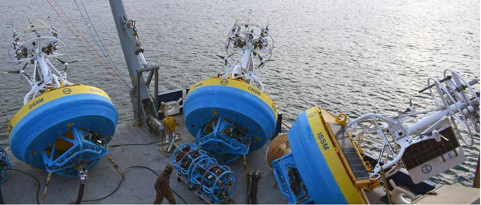
Top Feature Image: Three OOI Coastal Surface Moorings stand ready on deck as the R/V Neil Armstrong prepares for departure for a Pioneer Array deployment off the coast of New England. Each fully instrumented mooring weighs in at more than 8,000 pounds, making it necessary to carefully coordinate their movement on deck and deployment. Only one of these will be deployed in the Southern Mid-Atlantic Bight during the initial test deployment. Credit: Rebecca Travis /© Woods Hole Oceanographic Institution

 ECU's Integrated Coastal Programs (ECU ICP) is a leader in coastal and marine research, education, and engagement. ECU ICP includes the Coastal Studies Institute, ECU's Department of Coastal Studies, and ECU Diving and Water Safety.
 The ECU Outer Banks campus is home to the Coastal Studies Institute.

